


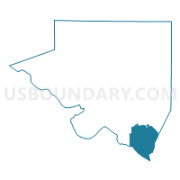
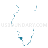
ROCKWOOD Voting District, Randolph County, Illinois
About
Outline

Summary
| Unique Area Identifier | 574056 |
| Name | ROCKWOOD Voting District |
| County | Randolph County |
| State | Illinois |
| Area (square miles) | 28.48 |
| Land Area (square miles) | 25.91 |
| Water Area (square miles) | 2.56 |
| % of Land Area | 91.00 |
| % of Water Area | 9.00 |
| Latitude of the Internal Point | 37.85820670 |
| Longtitude of the Internal Point | -89.70847680 |
Maps

Graphs
Select a template below for downloading or customizing gragh for ROCKWOOD Voting District, Randolph County, Illinois


Neighbors
Neighoring Voting District (by Name) Neighboring Voting District on the Map
- Belgique Voting District, Perry County, MO
- BRADLEY - CAMPBELL HILL Voting District, Jackson County, IL
- CHESTER 1 Voting District, Randolph County, IL
- CHESTER 3 Voting District, Randolph County, IL
- DEGOGNIA Voting District, Jackson County, IL
- WINE HILL Voting District, Randolph County, IL
Top 10 Neighboring County Subdivision (by Population) Neighboring County Subdivision on the Map
- Chester precinct, Randolph County, IL (9,314)
- Bradley township, Jackson County, IL (1,951)
- Bois Brule township, Perry County, MO (540)
- Wine Hill precinct, Randolph County, IL (435)
- Rockwood precinct, Randolph County, IL (270)
- Degognia township, Jackson County, IL (153)
Top 10 Neighboring Place (by Population) Neighboring Place on the Map
Top 10 Neighboring Unified School District (by Population) Neighboring Unified School District on the Map
- Perry County 32 School District, MO (17,763)
- Chester Community Unit School District 139, IL (11,160)
- Trico Community Unit School District 176, IL (6,525)
- Steeleville Community Unit School District 138, IL (3,097)
Top 10 Neighboring State Legislative District Lower Chamber (by Population) Neighboring State Legislative District Lower Chamber on the Map
- State House District 116, IL (110,789)
- State House District 115, IL (105,561)
- State House District 157, MO (37,900)
Top 10 Neighboring State Legislative District Upper Chamber (by Population) Neighboring State Legislative District Upper Chamber on the Map
Top 10 Neighboring 111th Congressional District (by Population) Neighboring 111th Congressional District on the Map
Top 10 Neighboring Census Tract (by Population) Neighboring Census Tract on the Map
- Census Tract 103, Jackson County, IL (3,115)
- Census Tract 9513, Randolph County, IL (3,057)
- Census Tract 9510, Randolph County, IL (2,772)
- Census Tract 4701, Perry County, MO (2,520)